
|

|
Some handy information about Hawaii Island
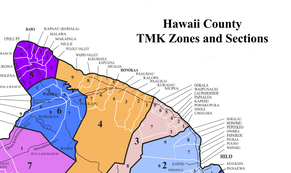
NeighborhoodsThis map shows approximate location for most of the major roads and neighborhoods on Hawaii Island.
|
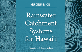
Keep your drinking water safe!College of Tropical Agriculture & Human Resources report on Rainwater Catchment Systems
|
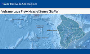
What Lava Zone Am I In?A lot of hearsay on what lava zone is where. Let the State of Hawaii tell you officially with this easy to use map.
|
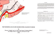
USGS Lava-Flow Hazard Zones
A generalized view of Hawaii Island's lava hazard zones. See also the Hawaii Statewide GIS site link above
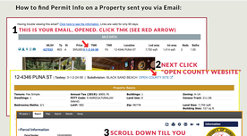
For Sale - Check Permit Status
Click the link below to view a help document for how to check permit status on reports you receive from us via email. There are other methods also. Just ask!
Title & Tenancy
What type of ownership should I designate on the deed? This document describes your options, which you should choose with guidance from a knowledgeable attorney and your Escrow Offer. 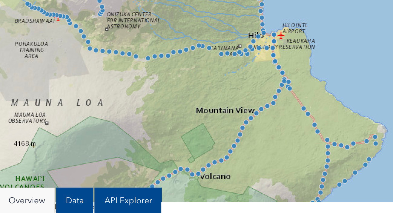
Mile Markers in Hawaii
Ever wondered what the nearest mile marker is? Or been given directions based on them. Here's a State resource to help you locate Mile Markers in Hawaii. |

Find out what your home's worth
Contact Jeff to find out what you home is worth.
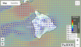
What's the Wind Today?
What direction is it blowing in Hilo? How strong is to today.
Live wind pattern map to you can see where to fly a kite or surf. 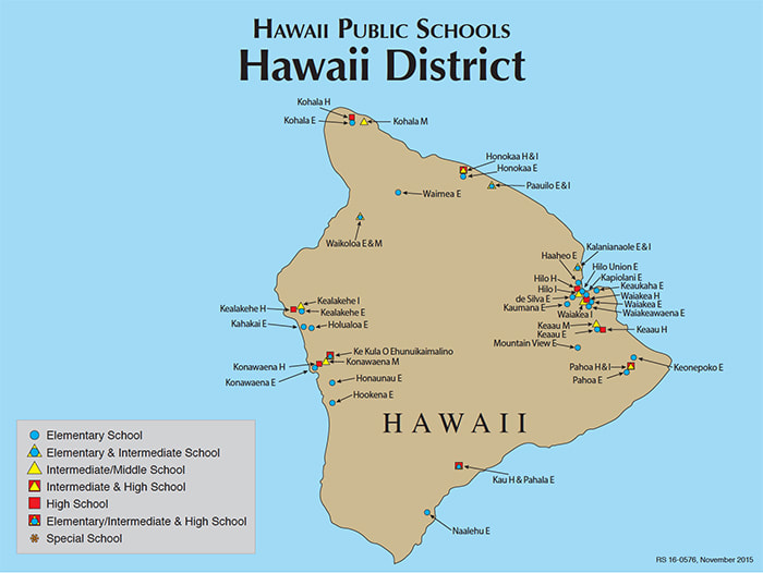
Locations, enrollment, more.
Home Insurance in
Lava Zones 1 & 2 Wondering about insurance in Lava Zones 1 & 2? Listen to the expert, Corina Hill, with Atlas Insurance Agency Corina Hill, CPCU, AIC, AINS, AIS Senior Sales Account Manager Personal Lines (808) 533-8613 Email: [email protected] 201 Merchant Street, Suite 1100 | Honolulu, Hawaii 96813 (video info subject to change - ask Corina!) |
Tsunami Evacuation Zones
Click the button below to input a specific address and see if it's in an tsunami evacuation zone.
Cool! Interactive Rainfall Map
The University of Hawaii has created this super cool, interactive rainfall map. Click your neighborhood to see how thirsty the plants are!
School Finder
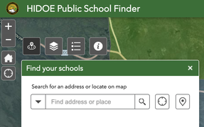
Click here to go to the Hawaii Department of Education School Finder website. You'll be able to enter you new home address to see where your kids will go to school.
|
|
What's your home worth? Did you know you can ask Team Aloha Boys to provide a professional market evaluation of your home here in Hawaii? The Team can provide you an overview of property values and sales of comparable homes in your area. Email Jeff today. Or, give me a call from your cell phone - click Jeff Really, it's free. Click HERE |

|
What Lava Zone Am I In?
What lava zone am I in?
What lava zone is the house I'd like to buy in?
It's darned hard to find someplace on the internet to determine what lava zone a particular home is in. While a few Realtor® websites are willing to state what lava zone certain subdivisions and areas are in, most won't.
Why? Largely because of how the original surveys determined the zone, and some misunderstanding about what it actually means.
It's difficult to find a high resolution copy of the USGS (U.S. Geological Survey) Miscellaneous Field Studies Map MF-2193, as it's been copied in poor quality and distributed by so many websites over the years, its a challenge to even read the legend. You can find the high resolution .PDF on the www.AlohaBoysProperties.com website as a download, or go here to view it:
https://pubs.usgs.gov/mf/1992/2193/mf2193.pdf
The zones are determined in part by percentages of the area that have been inundated by lava over time. In Lava Zone 2, for example, 15% to 25% of the area has been covered by lava since 1800. And 25% to 75% of it has been covered in the last 750 years. Even 5% of Lava Zone 3 has been covered since 1800.
Here's what the USGS legend on their lava zone map says:
Zone 1-Includes summits and rift zones of Kilauea and Mauna Loa, where vents have been repeatedly active in historical time
Zone 2-Areas adjacent to and downslope of zone 1. Fifteen to twenty-five percent of zone 2 has been covered by lava since 1800, and 25 to 75 percent has been covered within the past 750 years. Relative hazard within zone 2 decreases gradually as one moves away from zone 1
Zone 3-Areas less hazardous than zone 2 because of greater distance from recently active vents and (or) because of topography. One to five percent of zone 3 has been covered since 1800, and 15 to 75 percent has been covered within the past 750 years
Zone 4 - lncludes ail of Hualalai, where the frequency of eruptions is lower than that for Kilauea or Mauna Loa. Lava coverage is proportionally smaller, about 5 percent since 1800, and less than 15 percent within the past 750 years
Zone 5-Area on Kilauea currently protected by topography
Zone 6- Two areas on Mauna Loa , both protected by topography
Zone 7 -Younger part of dormant volcano Mauna Kea . Twenty percent of this area was covered by lava in the past 10,000 years
Zone 8-Remaining part of Mauna Kea . Only a few percent of this area has been covered by lava in the past 10,000 years
Zone 9 -Kohala Volcano, which last erupted over 60,000 years ago
But, the map, despite being updated a couple of times, still doesn't give the user a very good idea of what zone they're in, particularly if they seem to be on near the border between zones.
This is where the Hawaii Statewide GIS Program (geographic information systems) can help you get that dart closer to the bull's eye. Their online mapping system overlays the USGS lava hazard zone maps onto an actual satellite map of the island.
It may take a minute to figure out the map, by hovering your mouse over the map at the top of the page, and using the "+ & -" clicks to zoom in & out. But, you'll get the hang of it, and determine pretty quickly which zone a particular location is in.
Here's the link to their website:
https://geoportal.hawaii.gov/…/volcano-lava-flow-hazard-zon…
Soon, we'll give an update on insurance availability in Lava Zones 1 & 2.
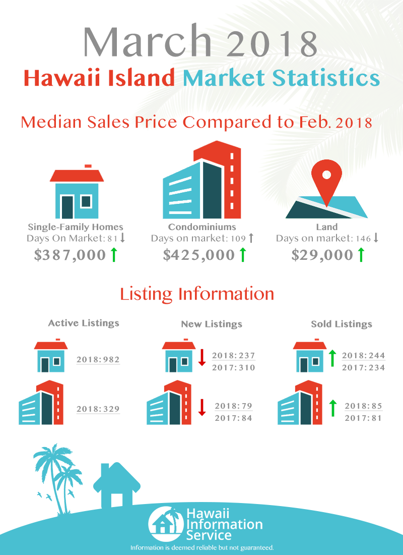
Year to Year Comparison of listings and sales of homes
In March 2018, New Listings were down 23.5% from 2017. But, Sold Listings were up by 4.1%.
In March 2019, New LIstings were almost identical to 2017, while Sold Listings were down by 18%.
Condominiums are also part of the two informations graphics below.
In March 2018, New Listings were down 23.5% from 2017. But, Sold Listings were up by 4.1%.
In March 2019, New LIstings were almost identical to 2017, while Sold Listings were down by 18%.
Condominiums are also part of the two informations graphics below.

|
|
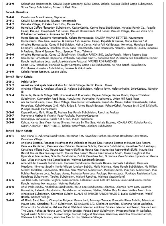
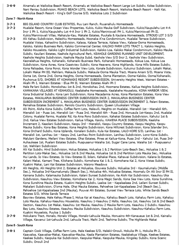
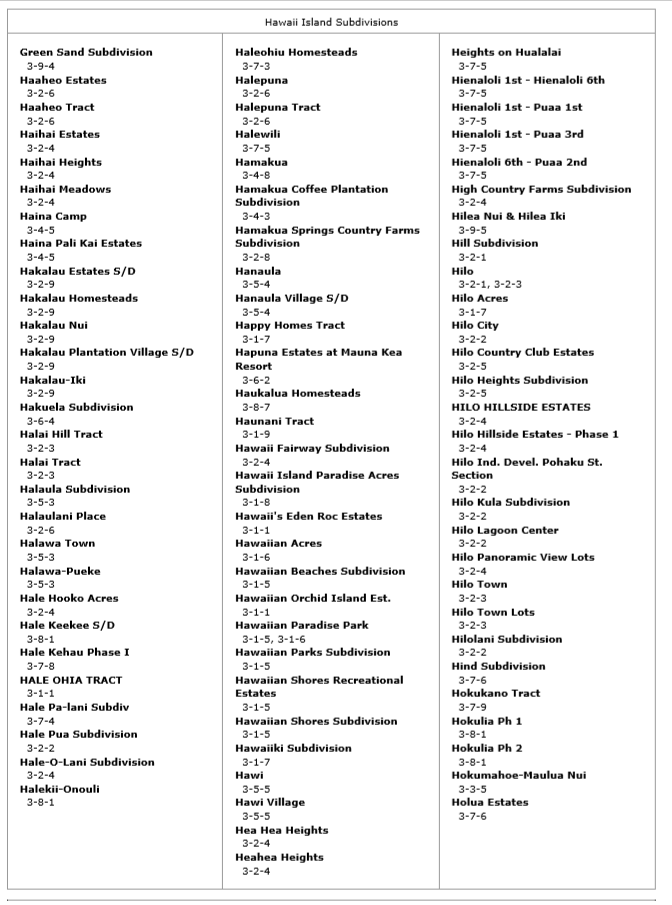
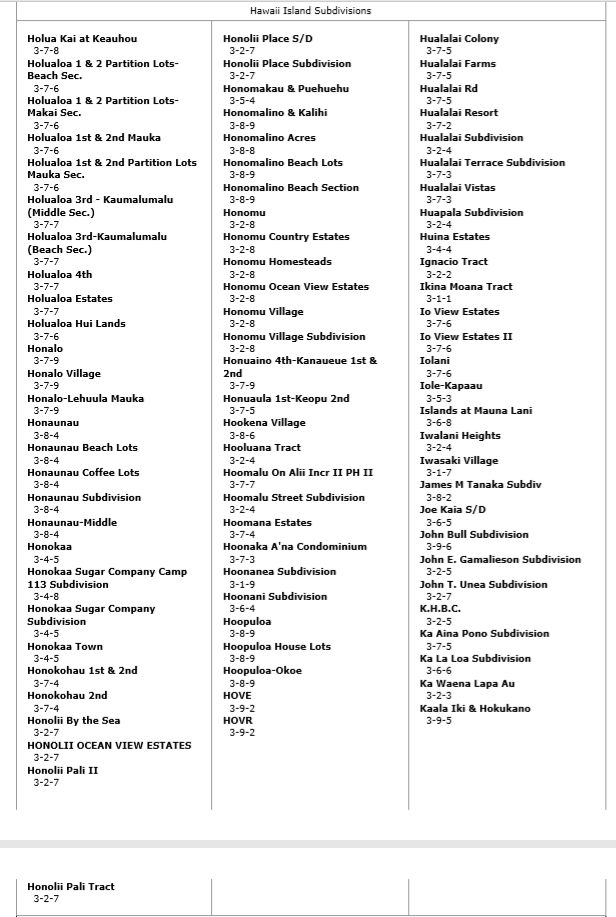
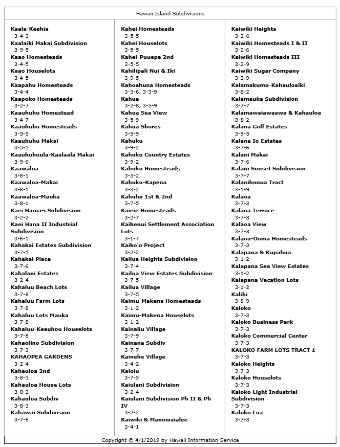
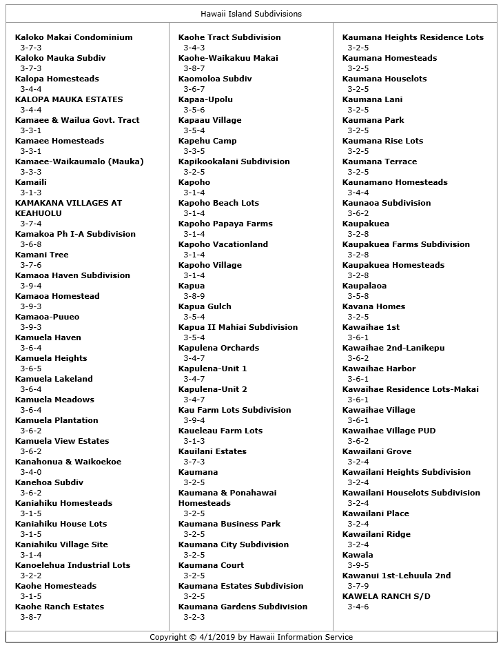
Become Familiar with the Big Island and its Districts
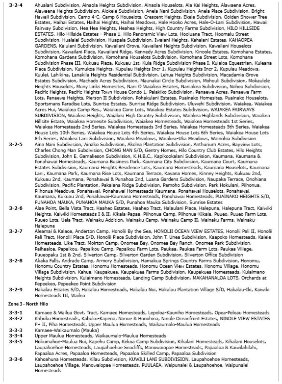
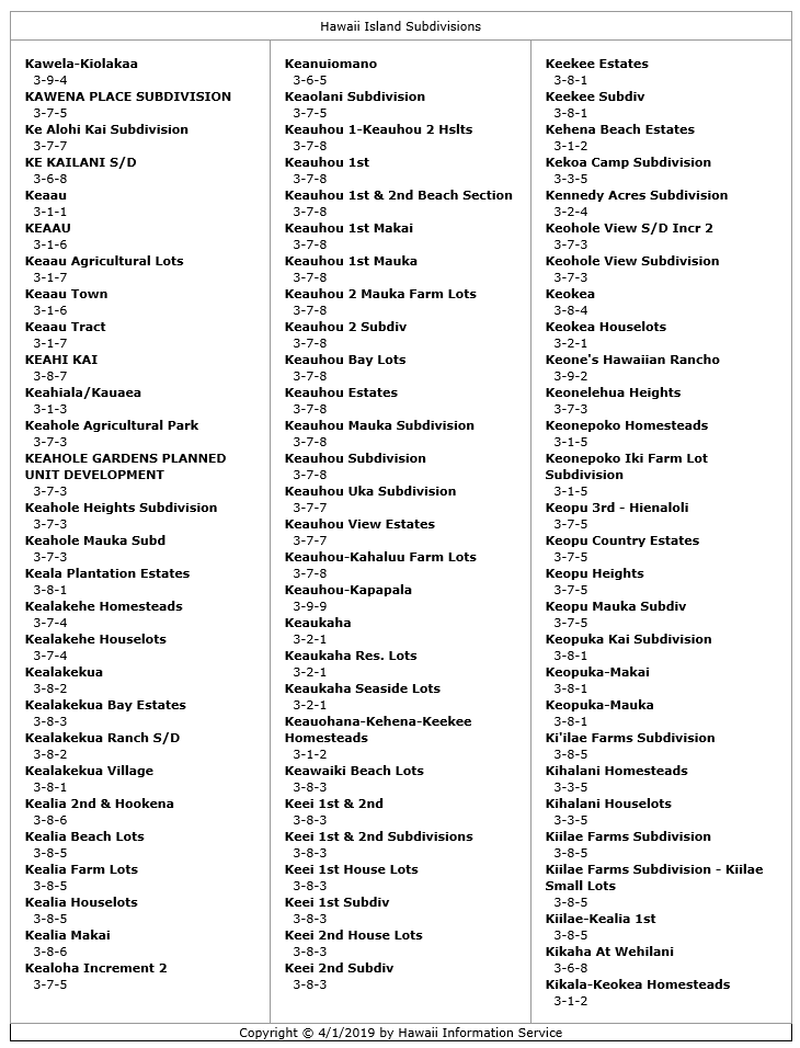
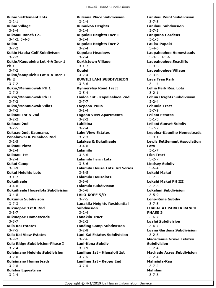
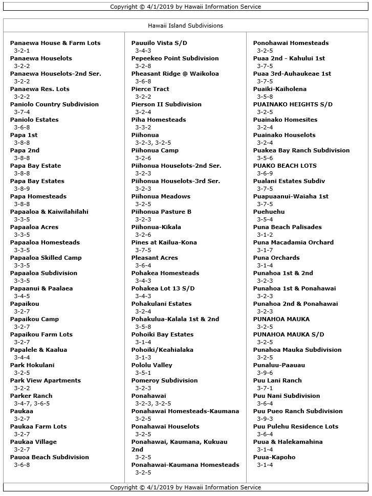
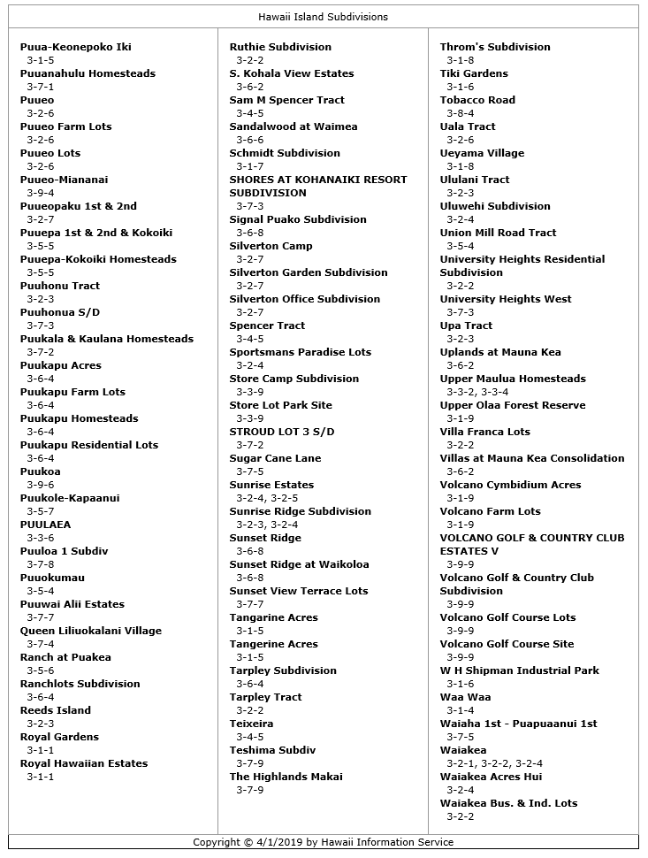
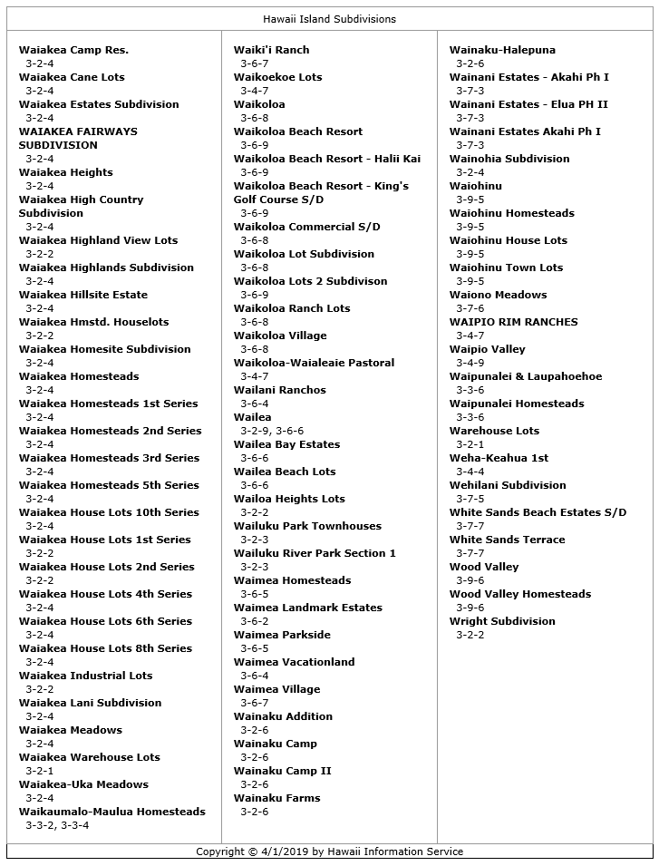
Big Island Subdivisions by District

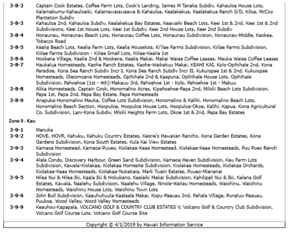
Big Island Subdivisions by Name


|
Jeff Calley RS-79890 Corcoran Pacific Properties 808-769-0525 - cell 818-925-7995 - fax [email protected] You can text me from your computer! Keep it short please! [email protected] |
Broker: Corcoran Pacific Properties 64 Keawe St, Hilo HI 96720 | RB-24007 | Website by Hawaii Information Service
Though deemed generally reliable, content on this website is designed to provide information generally available to the public and is not intended to provide authoritative information. All suggestions, opinions, and information about processes, procedures, vendors, partners and activities provided throughout are not recommendations and are not conclusive. Each visitor to this site must do his, her, or xyr own due diligence in selecting services, products and activities. You have options and your situation may differ, requiring exploration of multiple possibilities to get the best outcomes. Neither Corcoran Pacific Properties, Team Aloha Boys Properties, Locations nor any of its Agents, Principles, or Management shall be held responsible for results of services, activities or experiences you engage resulting from information on this website, its collective pages or links to other websites. Help us keep this website as current as possible. Report any discrepancies to [email protected]